

3 The Burr Trail
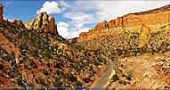
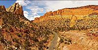
Central Utah Summer 2015Like the Hole in the Rock Trail, the Burr Trail was created for specific commercial purposes. John Atlantic Burr was moving large numbers of cattle between Boulder and Lake Powell, so he made a long trail South.
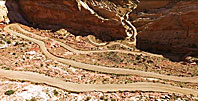
When he came to the rim of the huge escarpment on which Boulder and Escalante are located, he had to create a switchback road to reach the valley below; that switchback road is still a marvel today. These days, the Burr Trail through Long Canyon is a tourist attraction, and the rest of the road is paved almost to the switchbacks.
When one stands at the top of the switchback road, the magnitude of Burr’s challenge and accomplishment are awe-inspiring.
As a geographic note: the Burr Trail winds South out of the town of Boulder.Please look at previous trip.
The Notom road begins far to the east, Near Caineville on the East side of the Capitol Reef National Park. Those two roads meet at the switchback, as you will see in the next gallery.Aerial Photography Using Drones
 |
 |
 |
 |
Carl Roessler
P.O. Box 33668
Las Vegas, NV 89133
voice: 702.562.0226
fax: 702.562.0227
| Return to Home Page | E-mail Carl Roessler: divxprt@cox.net | Photos |
|---|
All material in this Web Site is Copyright © Carl Roessler
2023 - All rights reserved.
Maintenance by Patricia
of Visual Ad Worx
Modified 11.08.23