1 Burr Switchbacks
Central Utah Summer 2021

The Burr Switchback Road and the Waterpocket Fold

Attempting to do a definitive presentation of John Atlantic Burr’s amazing road and the 100-mile-long Fold are challenging for the drone. The drones does fine at altitude, but as you will see, navigating down for a landing so close to the cliffs is hazardous.

Looking down from the drone, I couldn’t find my car in the shadows, so I chose what I thought was a safe strategy--landing on the sunlit section of the road. There is very little traffic on this road, so I thought it was safe to land in the Sun and then drive to where the drone would be sitting in the middle of the road.

As you will see in video 9, that was almost a fatal error for the drone!

Aerial Photography Using Drones
Waterpocket Fold Panorama
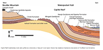
Rock Layers At Waterpocket Fold Outside Eastern End Of Burr Canyon

John Atlantic Burr was born while crossing the Atlantic in 1846, and lived with his family in Salt Lake City before moving south to establish the town of Burrville, Utah, in 1876. He established the Burr Trail across extremely rugged territory, including Waterpocket Fold, Burr Canyon, and Muley Twist Canyon as a way of moving cattle between lower winter grazing ranges on the east side of Waterpocket Fold and higher summer grazing ranges on the west.
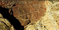
John Atlantic Bur's Cattle Road

Return to Home Page E-mail Carl Roessler Photos

All material in this Web Site is Copyright © Carl Roessler 2021 - All rights reserved.
Maintenance by Patricia of Visual Ad Worx
Modified 09.29.21